Only an hour and a half away, in Keizer, Oregon, was the one and only In-N-Out burger in the entire state. The mecca of burgers.
Fish Lake Valley Hot Springs

In Nevada, kinda enjoying Vegas, but also kinda not. (if you know what I mean) It didn’t help that I got a speeding ticket for 5 miles over the limit. 5 miles… ugh. Damned revenuers and quota fillers. :) Pretty much tainted my entire time here. We’re really not into the gambling thing so much anymore, and after visiting friends in the area and hitting a couple nice restaurants and other various points of local interest, we find ourselves looking for a place to spend a birthday that isn’t all citified and Vegas-y. A little Google-fu, some mapping magic and a freecampingsites.com assist and a destination presents itself. A remote, hopefully picturesque mineral hot-springs out in the middle of nowhere in Tonopah, Nevada.
At 4 to 5 hours away, it’s going to be a bit of a haul, but the research is looking good so the decision is made. Remote will prove to be an apt description. Even the drive there is sparsely populated. North on the 95 to the 256, then east. The landscape is desert breathtaking, with brilliant blue skies filled with rolling clouds, foothills and snow covered mountains in the distance with jagged, windblown buttes jutting up all around us. Once we hit the 256 the terrain changed to a flatter, even emptier desert with distant hills and a steep grade we were headed towards.


As we climb towards the summit we start to hit snow, and I can count on one hand (a hand with a fairly bad table saw accident) the number of vehicles we see. At Lida Summit, (7400 ft) we stop for a leg stretch and scenery check. Yup, there’s scenery. Coming down the other side, we drop back down to around 4500 ft or so, and eventually start to see distant ranches and sparse signs of civilization. Surprisingly, we dip back into California somewhat near Bishop, but the road turns north and back into Nevada. I think we were in Cali just long enough to sneeze.

Finally, we hit Dyer, the last town before our turn and stop at the market there for a few last minute necessities and a destination check. Yes, about 10ish miles north is the road we’re looking for. Dyer does have an RV park for dumping and water refills if needed. We hit the unnamed (on the map) road with the smallish white sign indicating the Gold Mining turnoff and we’re back to gravel/dirt road (Kathy’s favorite) for another 7 miles. I don’t mention the distance.

We pass it by the first go round and have to backtrack, as it’s up on a rise on the left hand side of the road and I miss it in the first drive by. Once we’re there though, wow. Picturesque to say the least, and yeah, this was well worth the trip.
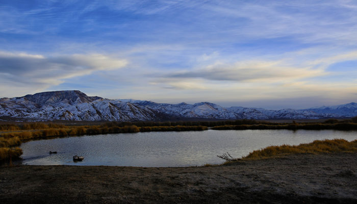
There’s one other vehicle on site, a lone guy with a pop up tent thingy in his truck bed, but other than that we have the entire place to ourselves. Over the four days we were there we saw two other rigs pull in, and one of those was just a stop by. I’m sure this is because it’s early February, and this place probably hops when the weather warms up, but it really wasn’t that cold for us, (68-70’s day, and 45ish at night) and the hot springs was wonderful. 95 to 98 degrees with a pretty little outflow to a small, duck and geese filled pond behind the spring. If we didn’t need to be back in Southern California shortly we would be extending this stay quite a bit.
This is definitely on our must revisit (and stay longer) list next time we’re in Nevada, and there are also a number of other hot wells and springs in the

area for future exploration. Some are commercialized, but some are off the beaten path like this one and worth a look. For now, we are on to Southern California.
Related Posts


This Post Has 0 Comments